With thousands of miles of tidal coastline, and the combined threats of storm surge and sea level rise, Maine’s coastal communities have a critical need to understand how weather and sea level contribute to flooding, erosion, and damage to their shores and coastal infrastructure. Help your community gather important flood impact data to inform resilience decisions.
- Read through the Prep & Collect tab on this site to familiarize yourself with the data collection protocol. We recommend printing and bringing along a data collection sheet in case you have no service or wifi in the field.
- Head to a coastal flood monitoring site (or anywhere along the coast) with a camera/smart phone and a friend – safety first!
- Take photos of the high water (or evidence of high water) that you’re observing and make note of the weather and broader flood impacts.
- Click on the Contribute tab to document your observations and upload your photos. You can use a computer to submit your observations once home, which may be easier than using your mobile phone.
Beyond building awareness of the often-invisible flooding occurring increasingly often in our coastal communities, data from this project is employed by planners, emergency management personnel, and flood forecasters in their work.
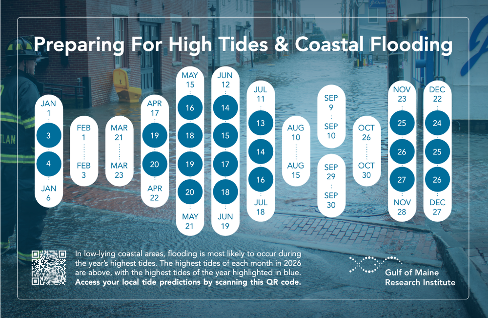
This Year's Highest Tides
Check out when the highest tides are projected to occur in 2026.
Additional Project Resources
Get involved, learn more, and bring the project into your community!
Land trusts, conservation groups, environmental ed centers, and community groups host coastal flooding educational events and coastal meet-ups all across Maine.
Interested to host coastal meet-ups in your area and engage your community in this project? The Community Engagement Package provides outreach and communications tools, instructions for hosting coastal meet-ups, brochures, and more!
Questions?
We'd love to connect with you along the way!
Contact [email protected] for additional information and support accessing resources, finding events near you, or getting involved as an organization.