Group
&
Individual

Inland Flooding: Rising Above Rising Waters

What weather and water level conditions are associated with inland flooding in our community? What areas are most vulnerable and critical to our community?

Why this matters

Maine is getting wetter faster than much of the rest of the country, and Oxford County is getting wetter faster than most other parts of Maine. Communities are already experiencing the impacts of extreme weather. The purpose of this project is to engage community members in monitoring flood prone sites and to document flood impacts and stories of how communities are coming together to address increasing flood challenges.

Partners
  • Center for an Ecology-Based Economy
  • Androscoggin River Watershed Council
  • Oxford County Emergency Management Agency
  • The Nature Conservancy
  • Gulf of Maine Research Institute
Season

Year-round

Inland Flooding: Rising Above Rising Waters

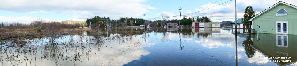
We invite you to make and share observations of river flooding or evidence of high water and share your opinions about the impacts you’re observing.

Observations are particularly helpful when storms or unusual wet weather is predicted. Always remember to be safe and smart!

Photograph of flooded buildings with water flowing from the buildings into a river with mountains in the background

Getting Started

Required Materials:

  • A mobile device (smartphone). With WiFi or cellular data, you can take photos and upload your observations from your phone by tapping the Contribute tab.

You can also use a laptop or desktop computer to submit your observations, which may be easier.

OR

We strongly recommend bringing a data collection sheet in case you have no cell service or WiFi in the field.

What You Do:

If you do not already have an account, create an account at https://investigate.gmri.org/ and click Register. We recommend doing this at home before heading out into the field!

  1. Head to an inland flood monitoring site (or anywhere you are or have observed flooding) with a camera/smart phone and a friend – safety first!
  2. Take photos of the high water (or evidence of high water) that you’re observing and make note of the weather and broader flood impacts.
  3. Open Ecosystem Investigation Network on your phone, laptop, or desktop. Click on the Contribute tab to document your observations and upload your photos.
  4. Click the View Data tab to see your and others' inland flood observations.

After you submit your observations in the field, you can add and update your observation afterwards until the observation has been reviewed and locked.

Project Owners

Roberta

Roberta Hill

Center for an Ecology-Based Economy

View Bio

Project Partners

Center for an Ecology-Based Economy
Androscoggin River Watershed Council
Oxford County Emergency Management Agency
The Nature Conservancy
Gulf of Maine Research Institute